Fullerton Wire Center Service Area Boundaries
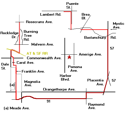
Fullerton Central Office
Location:
South side of Amerige Ave. between Harbor Blvd. and Pomona Ave.
Service Area Boundaries:
- From ??? to Rosecrans at the Fullerton/Buena Park city limit south to A.T. & S.F. Rail Road.
- From Rosecrans at the Fullerton/Buena Park city limit south to A.T. & S.F. Rail Road.
- Northwest along A.T. & S.F. Rail Road to the Fullerton/Buena Park City limit.
- South along city limit and Dale St. to a point North of Commonwealth Ave.
- East behind buildings on north side of Commonwealth Ave. (those buildings are in the Buena
Park service area)
- South along city limits.
- East along city limits.
- South in a straight line along city limits, through city along city limits again, and through
city again to the 91 freeway. The line is west of Franklin Ave. and east of Meade Ave.
- East along the 91 freeway to Raymond Ave.
- North along Raymond Ave. to south of the buildings on Orangethorpe Ave.
- East behind the buildings on the south side of Orangethorpe Ave. to Placentia Ave.
- Northeast along Placentia Avenue to the 57 freeway.
- North along the 57 freeway to a point lining up with Mystic Ave.
- West from the 57 to a point south of Bastanchury Rd. and west of Brea Blvd.
- From a point south of Bastanchury Rd. and west of Brea Blvd. to Bastanchury Rd. and a
point lining up with Puente St. (the one along the Fullerton-Brea border), the research materials
contain no data
- From Bastanchury Rd. and a point lining up with Puente St. (the one along the Fullerton-Brea
border) north along Puente St. to a point behind the buildings on the south side of Lambert Rd.
- West behind the buildings on the south side of Lambert Rd. to ???.
??? — These areas border other areas not covered by the research materials, so boundaries could
not be established.


